Understanding CoMapeo’s Core Concepts & Functions
What is CoMapeo?
CoMapeo is a mapping and territory-monitoring tool created together with Indigenous communities. It was designed to respond directly to their priorities: documenting what is happening on their lands, telling their stories, and protecting their rights.
Unlike many digital tools that are expensive, complex, or dependent on the internet, CoMapeo is simple to learn, works offline, and keeps full control of information in the hands of the community. This means it can be used in remote areas, on affordable phones, and by people with different levels of digital experience.
Because it was co-designed with Indigenous partners across multiple continents, CoMapeo reflects their knowledge and way of working. Communities use it to map cultural sites, monitor environmental threats, record oral histories, and strengthen their stewardship of the land.
At its core, CoMapeo is more than a piece of software: it is a tool for accessibility, autonomy, and collaboration — enabling frontline communities to gather and share information safely, in ways that serve their own goals. Key features of Mapeo
- Simple to use and learn Even if you have never used a smartphone phone before, you can learn to collect data, GPS points and photos with Mapeo Mobile in a few hours. Mapeo Desktop does require some computer skills, but has a simple interface with a limited number of features. For more complex analysis or mapping work you can export your data to other tools. The simplicity of the tools helps support wide community involvement and ownership of projects.
- Works in completely offline environments All data collected or created with Mapeo is stored directly on your device in Mapeo's embedded database, without the need for an internet connection or centralized server. Users of Mapeo Mobile and Desktop can synchronize or exchange data over a local Wi-Fi network. The data never leaves your local Wi-Fi network and does not require an internet connection. Mapeo Desktop can also exchange information via a file using a USB drive.
- Uses a peer-to-peer database All the data you collect using Mapeo is stored locally on your device, not on a server or on the internet. When you synchronize with other Mapeo users in your project, you each get a copy of the data that each person has collected, so every device ends up with a complete copy of all the data in the project.
- Highly customizable You can customize the language, maps and information you collect. You can add detailed offline maps of your area, and change the icons and questions used for data collection. Mapeo has been translated into a number of languages already and anyone can add more.
- Secure, unfalsifiable data All data collected with Mapeo has encrypted logs that can be verified for authenticity. Similar to a blockchain, data is secured by cryptographic proofs, so you can verify that no record in the log has been changed or tampered with. Private projects can be created using secure project keys which limit who one can synchronize data with.
What is possible when mapping as a team?
Mapping with others makes the work more powerful. When a group collects information together, you can cover more ground, include different perspectives, and build a shared record of what is happening on your land. It also helps distribute responsibility so no one person carries the entire workload.
CoMapeo is designed for teams of people to work together to collect data while walking their territory, and to share it with each other without the need for internet access.
💪🏽 Learn about the impacts that communities can have when mapping as a team in our impact report: Ten years of Mapeo
What are CoMapeo’s core concepts and functions?
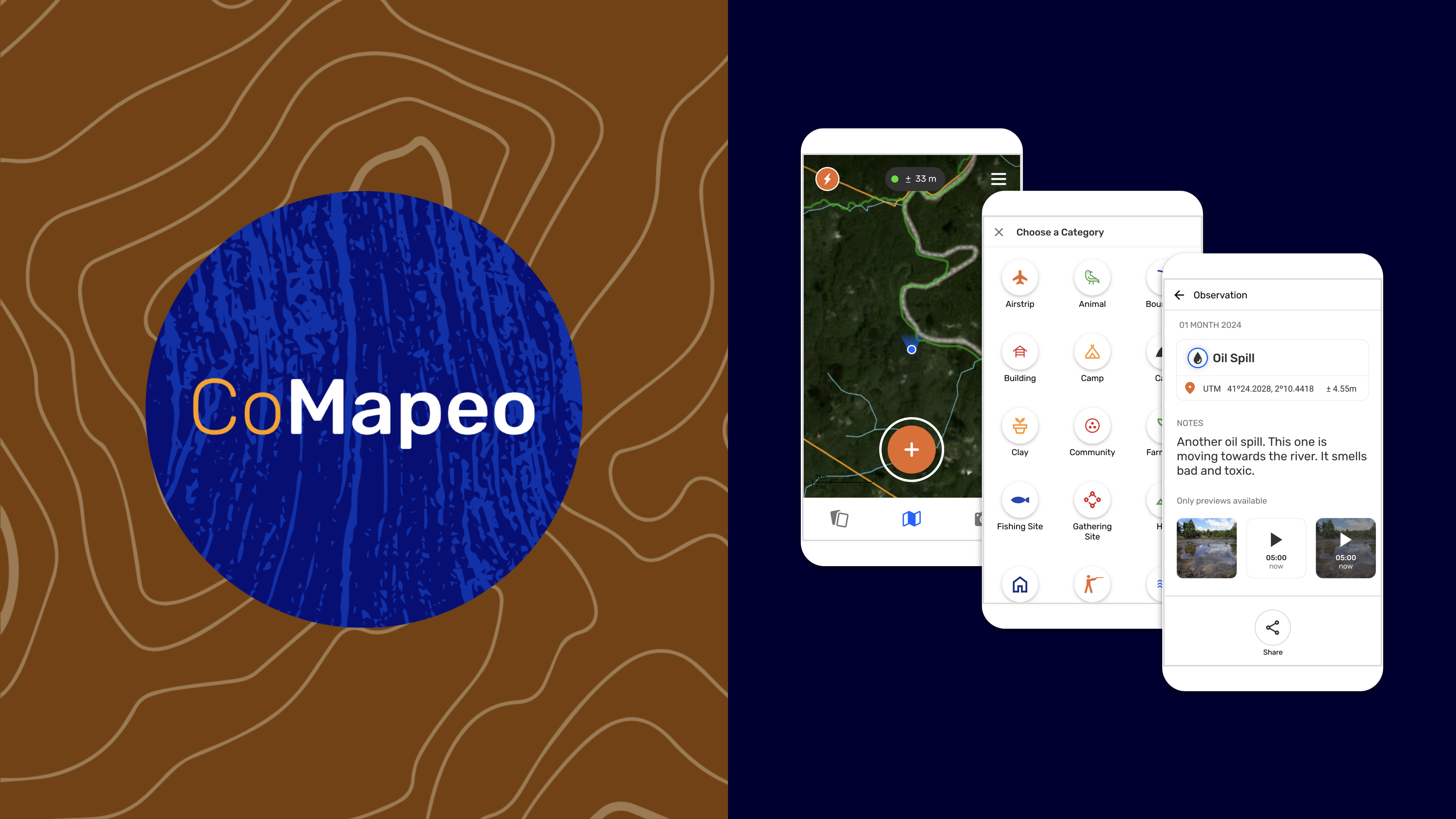
- Observations are the main way to collect information in CoMapeo. Besides the location, timestamp and category, they can also include photos, audio recordings and details.
- Tracks let you record paths or boundaries as you move across the land. They are useful for documenting trails, patrol routes, rivers, or territory borders.
- Projects organize your mapping work, either individually or with collaborators. They define the categories, team members, and settings for how data is collected and managed.
- Exchange is how devices share and synchronize project data. It allows collaborators to keep their observations up to date, even without internet access.
Coming Soon
While we continue to improve CoMapeo there will be new releases, technical summaries and announcements to share
Relevant resources
Blog | Stability & Co-Design: Our CoMapeo Release Strategy
👉🏽 For general information, newsletter signup, and access to blogs about CoMapeo, visit comapeo.app
The directory was : docs/understanding-comapeos-core-concepts-and-functions
What happens with an & (look at address)